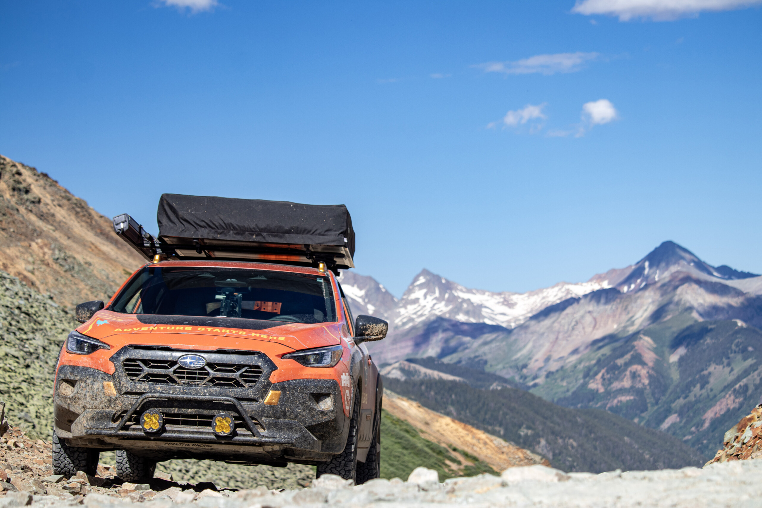
The TransAmerica Trail (TAT) may be the best adventure you can have in the lower 48 states. It will take you coast to coast with nearly half the journey being off pavement. My wife, Mercedes Lilienthal, and I just did the entire 7,100-plus mile crossing testing the limits of a 2025 Subaru Crosstrek Wilderness in the process.
What Is The TransAmerica Trail?
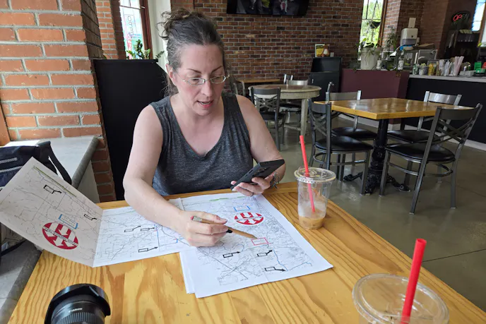
Mapped by adventure moto enthusiast, Sam Correro, the TransAmerica Trail was originally intended for adventure motorcycles, but the trip can also be done in four-wheel drive vehicles. The trail officially starts in Nags Head, North Carolina, and runs to Port Orford, Oregon, with optional segments sprouting from the route. Nearly half the cross-country route is off pavement. Paper and digital route maps can be purchased at transamtrail.com. We had both, with the GPX files loaded into our Garmin Tread Overland Edition.
Could We Complete TAT In A Subaru?
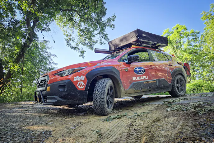
We always love underdog vehicles and using non-traditional rigs for added challenge. We chose to attempt TAT in a 2025 Subaru Crosstrek Wilderness on loan to us from Subaru of America. We added mild mods to give this all-wheel drive SUV more off-road capability and make it ready for camping. We expected the TransAmerica Trail would take 3 to 5 weeks to complete, and we weren’t sure if we could complete all of it with the Crosstrek.

Our Adventure Begins
Kicking off the journey, we packed our bags and flew from Oregon to pick the car up at Subaru’s headquarters in New Jersey. We then drove seven hours to Nags Head to the official start of TAT’s Atlantic Ocean Spur.
The eastern portion of TAT has less dirt than the west, but once into the Appalachians, we finally began to encounter less pavement.
The Appalachian Mountains offered tight, steep, dirt switchbacks and great scenery. The trails weren’t technical but required full attention. Recent storms toppled trees blocking trails, necessitating multiple workarounds. Over the entire trip, we deviated from the trail 39 times due to storms or storm damage.

Horribly Hot Weather And Our First Trails Through Appalachia
The farther we went, the more dirt we encountered, and the more rural it got. Appalachia was beautiful, but the weather was stinking hot, with temps in the 90s and sauna-like humidity. We never got rid of the heat. Of our 29-day trip, 28 days were over 90 degrees; six days were 100 or above.
We were apprehensive about our first few mountain roads in Appalachia. Would it be safe? What if we broke down? How long would it be until someone came along? Some “roads” hadn’t been driven in a while; the grass between the two-track was high. We drove for miles without seeing signs of civilization, except for old hunting shacks.
We rarely encountered anyone in rural areas anywhere. Thankfully, the few people we saw usually offered friendly waves. At no point in our 7,100 miles did we meet another person traversing the TransAmerica Trail. Other than passing through towns to get food or fuel, our contact with others was seldom.

Dodging Dodgy Weather Along The TransAmerica Trail
We had to escape severe weather for almost two weeks, from North Carolina to Oklahoma. We had back-to-back motel nights in Arkansas due to severe storms with hail, torrential rain, and 60 MPH winds. Battling the weather turned out to be one of our biggest challenges.

The First Technical Trail
Until Arkansas, we didn’t have many technical trail sections, until Warloop Road in western Arkansas. We’d been warned by the moto guys about it, but we had to check it out.
Warloop was narrow, somewhat overgrown, and mostly downhill. It had rock ledges, boulders, off-camber sections, and was slow going, but doable in part thanks to great spotting. Thankfully, we’d equipped our Crosstrek Wilderness with Primitive Racing’s front, mid, and rear differential skid plates. And they got used. We also upgraded to slightly larger BFGoodrich All-Terrain KO2 wrapped on wider Reika R15 Seeker wheels, Bilstein B6 struts and rear King Springs—it all helped.
Several drop-offs challenged the Subaru, despite its 9.3 inches of ground clearance. But the Wilderness showed how it’s an overachiever off-road on Warloop. Subaru’s X-MODE “Dirt and Snow” setting shined, and despite the car’s CVT and lack of low range, we conquered Warloop.

On To Oklahoma, New Mexico, and Colorado
Things flattened out in Oklahoma, however, there was widespread flooding. This necessitated deviations due to the occasional lake in the road, river in the trail, or conspicuously missing bridge. We were on the lookout for the state’s infamously sticky clay.
But after several more route deviations, Oklahoma’s stick-straight gravel farm roads let us make miles, a liberating feeling after crawling through Appalachia. It’d took us 13 days to get from North Carolina to Oklahoma. By comparison, Google Maps said it’d be a 20.5-hour drive if you took main routes. We averaged just 25 MPH over the previous nine days.
Oklahoma flew by, and we crossed the northeastern corner of New Mexico, and into Colorado.

Our Biggest Challenge: The San Juan Mountains
After going through south-central Colorado, the TransAmerica Trail took us to the San Juan Mountains. They would be our biggest challenge. Our first hurdle? Cinnamon Pass.
Cinnamon Pass was stunningly beautiful with brown and red hues mixed with towering pine trees and mountain peaks. It started easy with small bumps, shallow water crossings, and gentile ascents—we saw lots of Subarus. As our elevation increased, we encountered a sign reading “4WD Recommended.” Now we were the only Subaru.
Things got rockier with tight mountain switchbacks. We quickly climbed. The non-turbo 2.5-liter “boxer” four-banger engine started to get wheezy over 11,500 feet, but we were still ascending.
We made it to the Cinnamon Pass’ 12,640-foot summit. A man in a Toyota Tundra came over and asked, “How’d you get that up here?” inferring we must be slightly insane to attempt this in a Subaru. We’re seasoned off-roaders and, truth be told, other than being low on power, the Crosstrek Wilderness impressed us with off-road capability. The Primitive Racing Skid Plates were the stars of the show, proving crucial protection; our aired-down BFG KO2s were also awesome— and thankfully we never got a flat.

A No-Go Up California Pass
Next up was a grandiose attempt: California, Hurricane, and Corkscrew Passes. We got over Cinnamon, but knew these were higher and potentially more difficult, but we had to try. Plus, we hoped to get to Silverton, CO afterward to meet up with the Off Road Roos, an off-road Subaru group.
We drove past the ghost town of Animas Forks, and through California Gulch, one of the most beautiful places in the world. We arrived at steep switchbacks to ascend to California Pass at 12,930 feet.
The easier trail bypass was blocked by feet of snow, leaving only a steep, loose ascent to the next switchbacks. Despite X-MODE and our BFGs, at 12,500 feet facing a steep, short incline, the Crosstrek ran out of steam. The CVT paired with thin air didn’t give us the momentum we needed. We opted to run Cinnamon Pass backwards and go into Lake City for the night.

The Long Way Around
After Lake City we learned there was a 12.3-mile graded dirt road from Animas Forks to Silverton (onX showed this, but we missed it). Instead, we faced a more than 3 hour, 160-mile drive around the mountains to get to Silverton.
We stopped at Flower Subaru in Montrose to check out a vibration (a dented skid plate was vibrating on a heat shield). We then spent the day in Ouray, reaching Silverton the next morning, and heading to Ophir Pass to rejoin TransAmerica Trail.
Ophir Pass, at 11,790 feet, isn’t as high as Cinnamon Pass. It’s a huge, narrow, cliff-side shelf road littered with loose shale. It’s not hard, but it’ll quicken your pulse. The biggest challenge: oncoming traffic. Thankfully, we didn’t encounter any.

Moab Bound
We descended from elevation, catching U.S. 491 to Dove Creek, Colorado, where it was flatter and farm like, and over 90 degrees again. We pressed west reaching desert-like conditions, then jetted up to Moab, Utah, now well over 100, for dinner at Desert Bistro. We got an amazing camp spot in Moab’s Sand Flats Recreation area and spent the next day around town where the temperature hit our trip’s high of 111.

Dusty Utah, Into Idaho
We departed Moab via the Gemini Bridges trail, leading to remote dirt roads. We didn’t see a soul most of the day, sans a worker driving a road grader in the middle of nowhere. We still have no idea where he came from or where he was going.
We’d went through San Rafael Swell, which looked like a set from Star Wars or Dune with towering rock formations, cliffs, and petroglyphs.
The heat and dust continued as we drove down isolated dirt roads. There wasn’t anything to see, yet there’s everything to see. Another dry lakebed, a dusty camp, more hot evenings. Multiple sun-bleached antelope skeletons littered a dispersed campsite, which added an eerie feel.
Things got weirder the next day as we ran across “HELP” signs outside of Wendover, Utah, on a remote stretch of dirt. There we found a sobbing woman who lived alone off grid. Her car had a flat, her mobile phone and charger, dead. We charged her cell phone with our EcoFlow DELTA 3 power station and deployed our Starlink Mini so she could call her local tire company. They came out and got her rolling again. The desert can be a strange, scary, and unforgiving place. This was a reminder to be prepared.
Much like northwestern Utah, southern Idaho was hot, dusty, and barren. The mercury hit 100 degrees again as we drove hundreds of straight, lonely, gravel miles, some of which crossed military bombing ranges. The TransAmerica Trail proves there are still remote places left in the U.S.; and we think we saw all of them. In western Idaho, we’d join the Pacific Ocean Spur, the TAT’s last leg. However, we were far from done.

Our Oregon Trail
Oregon, our home state, was familiar territory, but the dirt roads off Interstate 84 were new to us. We saw remote ranches, far-off lakes, and desolate canyons before entering the dense Malheur National Forest.
We were no longer out-maneuvering severe storms, instead we were weaving around wildfires. In east-central Oregon, we saw smoke in the air—never a good sign. We pulled off, unpacked our Pelican case, and deployed our Starlink Mini. Maps showed we weren’t in immediate fire danger, but we pushed and opted for a motel in John Day, Oregon, out of abundance of caution.
The smoke subsided the next day as we wound through high desert trails that passed through pines on narrow dirt tracks. As we crossed US Highway 20 in the early evening, the air became thick with wildfire smoke thanks to a blaze north of us. Our air quality app said it was 30 times worse than a safe allowance. It was another motel night.
The air cleared the next day, and we zig-zagged through the Deschutes National Forest and its silt-strewn roads. Our Subaru left massive dust plumes behind us, looking like a smoking rocket despite our low speeds. A missed fuel opportunity led to yet another deviation through Umpqua Forest. Oh, and it was 100 degrees again. Luckly that night’s camp spot was shaded by massive pines.
It was at this point that we realized we could be done the next day. We could reach Port Orford and the Pacific Ocean tomorrow, complete with dinner at The Crazy Norwegian’s Fish & Chips.

The Last (Hard) Day On The TransAmerica Trail
Day 29, our last TransAmerica Trail day, proved challenging. We read western Oregon would be a struggle due to trail damage. Indeed, we encountered washouts, terrible old roads, and even a six-foot-diameter impassible sinkhole in the middle of NF-3353. Oregon wasn’t going to let us waltz across the finish line.
Thankfully, we found another route across the Coast Range. It was basically the only way. The twisty NF-5325 would turn into Elk River Road and took us into Port Orford to our sought-after fried fish victory dinner.
As we piloted our steadfast Crostrek Wilderness down the rocky, mountainous trail; it felt like an eternity. Suddenly the road got better; we saw people on bikes. There was pavement, more people and vehicles, and eventually a sign for US Highway 101. We became elated—we were five minutes away from the end of an epic adventure … and fish and chips.

We Did It: Finishing The TransAmerica Trail
Before we knew it, we were in Port Orford. Finishing the TransAmerica Trail was surreal. We did 7,163 miles from coast to coast, 3,184 of which was unpaved. We became accustomed to living on the road and saw parts of the U.S. most people will never witness. After dinner, we bought a bottle of bubbly to celebrate.
While the TransAmerica Trail isn’t the best-known route for four-wheeled 4x4s or AWD vehicles, it should be on your bucket list of overland trips. You’ll see the USA from a new viewpoint and likely have an adventure of a lifetime, without even having to get a passport. And yes, you can even do it in a Subaru.
Photos by Andy Lilienthal


You might also like
This Turbodiesel 1946 Dodge Power Wagon Packs 900 lb-ft Of Torque
This 1946 Dodge Power Wagon 4x4 has been custom built from the ground up. Features include four doors and a potent Cummins turbodiesel.

